
State Park digital maps now track you on the trail
Getting away from it all and traveling down a remote trail in the woods has all the makings for a great adventure. Unless of course you get lost.
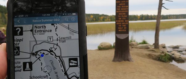
If you or someone you know is at all uneasy about this possibility, you may be interested to learn that special state park maps can now be downloaded onto an app called Avenza that displays a dot exactly where you are in the park. Yes, even when you’re deep in the woods with no cell or internet service.
It sounds quite amazing, but there are two hoops to go through to access the maps. They require a little preparation.
Do the following actions, which require internet access, before you arrive:
- Download the Avenza Maps app onto your mobile device
- Using your mobile device, visit the Avenza Maps webpage where you can click either the “Download on the App Store” or the “Get it on Google Play” button and complete the free download. When you open the app, you’ll need to complete the prompts to create your account.
- Go online to find the specific park or trail map and copy the URL
- Go to the DNR’s GeoPDF Downloader webpage for a list of all the available maps.
-
- Pro Tip: bookmark this page for future map access
-
- Choose “Maps” icon at the bottom of the page to open the filter list where you can choose “State Parks” and “State Trails”.
- Click on the map you want and click “download.”
- At this point your next step seems to vary depending on your device.
- Here’s what worked for us on Android:
The download app opens and you can click on the three dots to “open with…” and select Avenza Maps. Done! The rest of the steps are only necessary for iPhone. - Here’s what worked for us on iPhone:
Once the PDF opens and you see the map, copy the url
(Afton’s url is: https://gdrs.dnr.state.mn.us/gdrs/apps/pub/us_mn_state_dnr/mndnr_geopdf_download/State_Parks/Afton%20Summer%20GEO.pdf)
- Here’s what worked for us on Android:
- Go to the DNR’s GeoPDF Downloader webpage for a list of all the available maps.
- Open the Avenza Maps app and paste the URL into it (final step necessary only for iPhones)
- Click on the newly downloaded app on your mobile device to open
- Click the + at the top of the screen
- Click the last option of “Tap to enter a URL of a map”
- Paste the URL you copied from step two
- The map should appear in the list of “My Maps” in the Avenza app and ready to use in the field.
Do the following when you arrive at the park or trail:
- Open the Avenza Maps app on your mobile device and click the map
- Find the blue dot on the map–that’s you. Walk around and watch the dot follow you. No need for cell phone or internet service.
Learn more about these maps at the DNR’s GeoPDF webpage