
Stunning. That’s how most people think of Minnesota’s Lake Superior shoreline.
Yet, amid all the scenery, only a meager number of public beaches exist allowing people to stroll up to the water’s edge; giving a chance to gently step into the frigid water—well at least a toe or two.
With member support, Parks & Trails Council of Minnesota (P&TC) is working to alleviate this unfortunate deficiency by securing an important addition to Tettegouche State Park.
Boundary lines
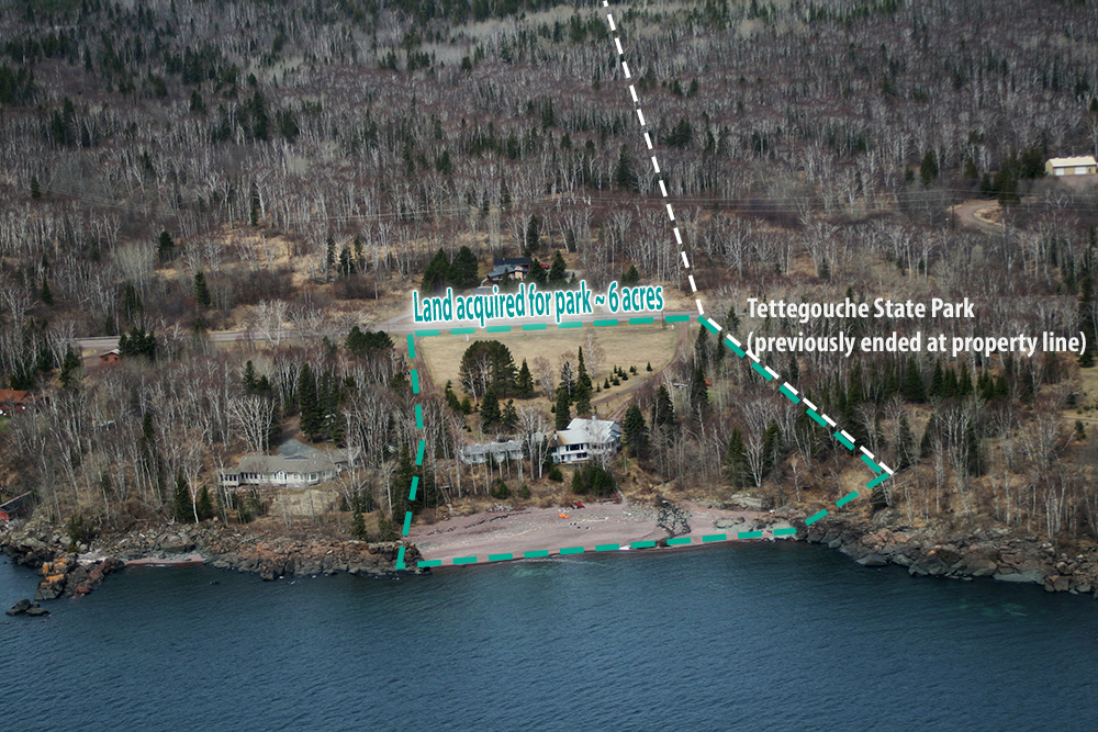
In November 2018 P&TC purchased the six acres of privately owned land adjacent to the park’s cart-in campground. This purchase was made possible in part by grants from the Henry S. Crosby Foundation and the Minnesota Environmental Fund. And it includes a rare pebble-beach. Soon park visitors will no longer encounter “private property” signs that keep them away from this coveted locale, as we work to transfer ownership to the park.
This beach will be a tremendous addition to the park. It’s located just a short walk from the main use-area of the park. Enclosed on either side by boulder-strewn shore, this beach is a relaxing place for skipping rocks or lounging on the shore and it allows easy launching for kayaks into Lake Superior.
About a half-mile up the rocky shore from here, at the mouth of the Baptism River, lies the park’s current pebble beach. It’s a popular place that will have pressure relieved once visitors have an additional place for beachcombing.
With the purchase completed, P&TC is now partnering with park staff to convey the land into public ownership. This could take up to a year, or even longer to complete.
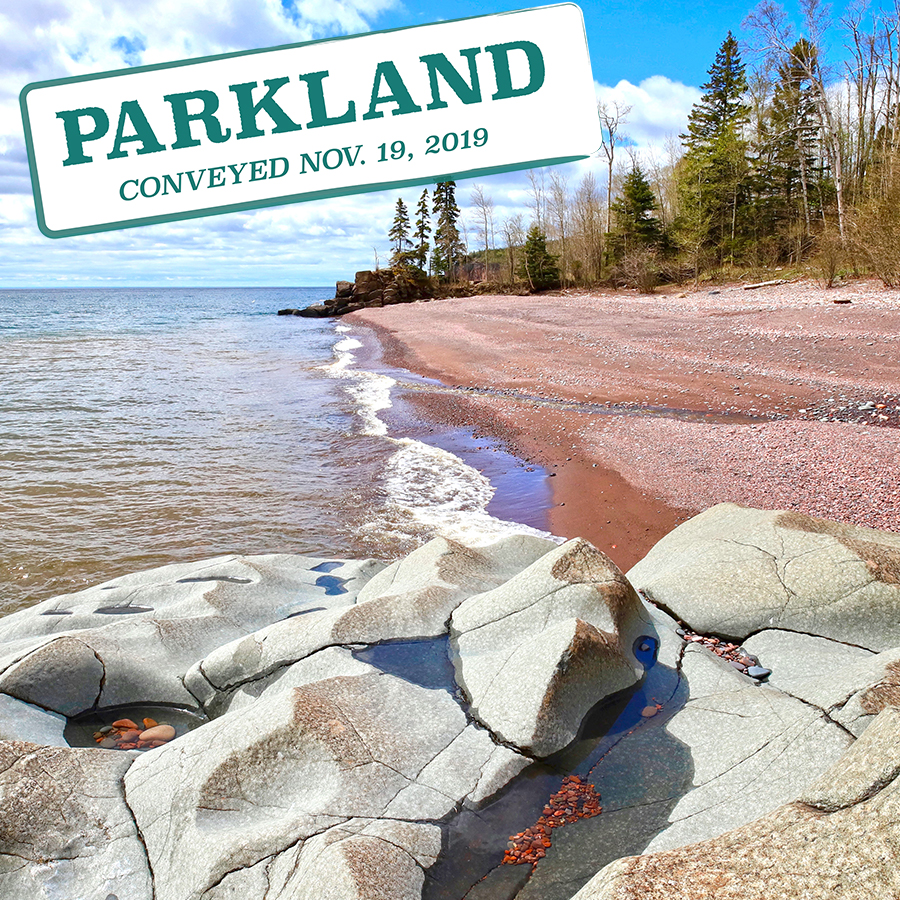
Pebble beach
The land has been developed with a small inn, which operated from about 1991 until a few years ago, when the owners decided to try to sell. P&TC staff began negotiations then, but the price was too steep, prompting fears that it would never be added to the park. However, with no other buyers in sight, negotiations began again.
While the land and beach are the main reasons to add this land to the park, there appears to be potential for the small inn to find a use in the park. Any such use will need to be determined by park staff in the future.
Fortunately, the park’s statutory boundary already encompasses this land, which eases the process for transferring ownership.
By acquiring the final few pieces of privately owned shoreline within the park, including this pebble beach, the final vision of the park will be close to completion. This is a vision that has evolved since the park’s creation in 1945.
How Tettegouche grew from a small wayside to its impressive size today
Tettegouche’s status as Minnesota’s fifth largest state park came about as the result of three major acquisition events. The original acquisition creating the park occurred in 1945 at the urging of P&TC founder Judge C. R. Magney; it was just 506 acres.
The story goes that he was driving along the North Shore and saw signs advertising “Lakefront Land for Sale.” Magney put up option money to hold the land until the legislature could act, which it did promptly.
The park remained small and mostly undeveloped until 1979, when the owner of Tettegouche Camp decided to sell his roughly 4,000-acre retreat. This rare opportunity extended the park inland to encompass several pristine lakes as well as the series of rustic-style cabins that were built circa 1911 as part of the recreation club retreat. The park’s name changed from Baptism River to Tettegouche State Park at this time.
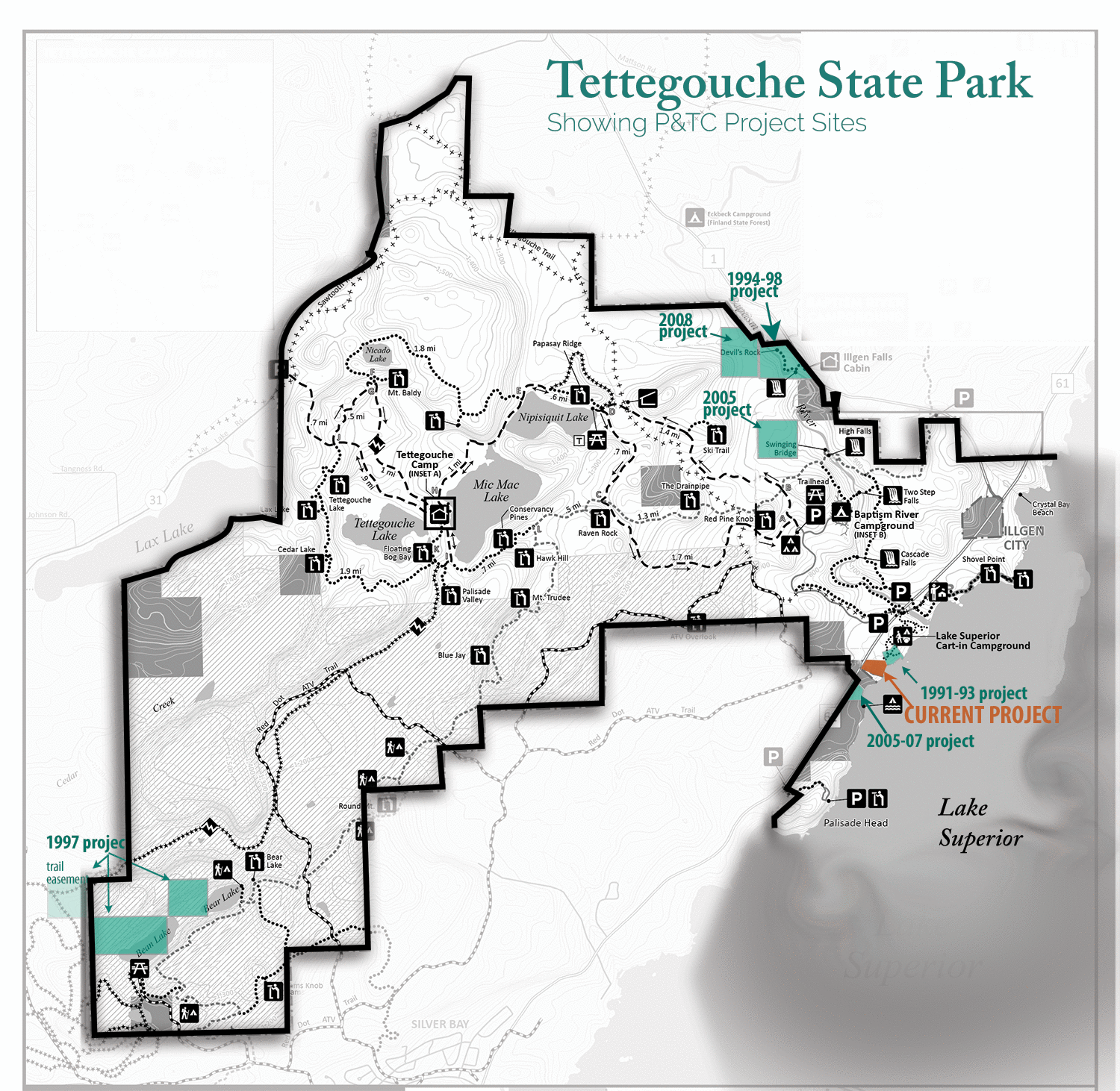 The latest major expansion happened in 1991, when the park more than doubled in size again to enclose 9,346 acres. This addition is known as Palisade Valley and was instigated in a joint effort by The Nature Conservancy and P&TC along with local recreation clubs (note: this land project is not reflected on the page 5 map since P&TC played an assist role rather than as the intermediary landowner). Most of the land was undeveloped and had been owned by a land company. Other parcels were owned by the county or other divisions of the DNR.
Interestingly, the Red Dot all-terrain vehicle (ATV) trail existed in the Palisade Valley before it was added to the park, prompting a compromise that designated this additional land as a State Recreation Area rather than State Park, and thereby allowed for ATVs’ continued use of the trail, even as they are prohibited in state parks.
That same year, the rocky, coastal overlook known as Palisade Head was also transferred into the park’s ownership. Since then it has been an isolated place, standing roughly one mile down shore from the rest of the park. Adding the land in between here has been a logical goal; one that P&TC has been working toward since Palisade Head was added.